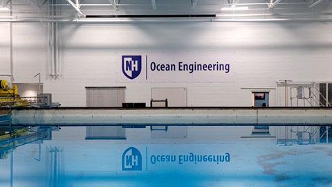
The Jere A. Chase Ocean Engineering Laboratory (COEL) is equipped with state-of-the-art testing facilities for underwater/ocean engineering. Resident faculty use the laboratory to conduct research in the areas of ocean engineering, ocean mapping, ocean acoustics, hydrogeology, and hydrographic surveying. Graduate and undergraduate students also take advantage of COEL to support their thesis work.
Tours of the facility are offered to prospective students and school groups. To schedule a tour at Chase Ocean Engineering Laboratory please email marine.information@unh.edu.
Marine Information
Email: marine.information@unh.edu
Phone: (603) 862-0672
24 Colovos Rd.
Durham, NH 03824
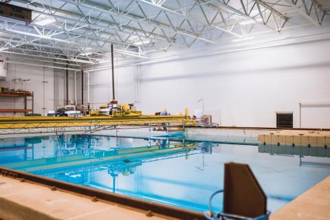
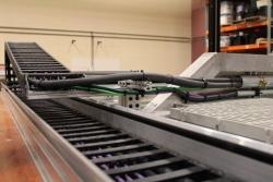
The engineering tank in the ocean engineering lab is a deep water testing basin. The 60 x 40 x 20 foot tank is used for a variety of experiments where simulating unobstructed, open water environments is required. Several additional components offer a variety of testing platforms. For example, the acoustic profiling tower can be used to test hydrophonic transducers for array shape and intensity. The mounting apparatus is capable of a full 360 degree sweep and 40 degree elevation at 1/10 degree resolution.
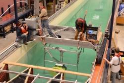
The tank measures 12’ x 8' x 120’ and enables research that involves towing test bodies and subjecting them to wave action. Wave action is possible using a hydraulic wave generator that can produce 2- to 5-second waves that are up to half a meter in height.
Data Acquisition
The tank includes an on-board electronics cabinet which provides enough continuous on-board power to run state-of-the-art measurement tools, e.g. particle image velocimetry (PIV). It also contains auxiliary servo drives for automated instrument positioning and/or turbine speed control. The data acquisition system allows streaming of measurement data over Ethernet to the main host PC, providing improved integration and synchronization.
Wave Maker
Wave creation is possible using a hydraulic flapper style wavemaker which can produce 2 to 5 second waves of maximum amplitude 0.5m. The wave destruction or ‘beach’ is a saw tooth style geo-textile construction which has an average 92% efficiency in the frequency range specified.
The tank's motion and control system is a belt-driven AC servo system, providing precise positioning capabilities with maximum acceleration and tow power.
The wave maker software allows tank users to develop regular or random seas using a variety of spectra such as Bretsneider, JONSWAP, and Berskon-Moskowitz. The 32-bit user interface is written in LabView and resides on the main control station PC.
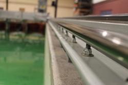
Linear Guides
The linear guide system has been upgraded with stainless steel linear shafts and bearings, providing a smoother and more finely adjustable carriage motion.
Motion and Control
The motion and control system has been upgraded to a belt-driven AC servo system, adding precise positioning capabilities with a tenfold increase in maximum acceleration and more than twice the available tow power.
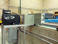
Data Acquisition and On-board Accessories
The newly installed on-board electronics cabinet provides enough continuous on-board power to run state-of-the-art measurement tools, e.g., particle image velocimetry (PIV). It also contains auxiliary servo drives for automated instrument positioning and/or turbine speed control. The new data acquisition system allows streaming of measurement data over Ethernet to the main host PC, providing improved integration and synchronization.
Turbine Test Bed
The turbine test bed is used to test a ducted axial turbine.
Ongoing research at JACOEL includes:
- Improving sensors used for hydrographic, ocean and coastal mapping.
- Developing new and innovative approaches for the 3D and 4D visualization of hydrographic and ocean mapping data sets.
- Developing collision-tolerant aids to navigation.
- Developing environmental modeling and oil spill response technology.
- Applying GIS technology to coastal meteorology and oceanography.
-

-

-

-

-
 Clinical ProfessorAffiliate Faculty, Earth SciencesEmail: Semme.Dijkstra@unh.eduPhone: (603) 862-0525
 -
-
-
 Affiliate ProfessorRESEARCH METEOROLOGIST/LAKE MODELERNOAA-UNH JOINT HYDROGRAPHIC CTREmail: John.Kelley@unh.eduPhone: (603) 862-1628
 -

-
-
 Assistant ProfessorOcean and Mechanical EngineeringEmail: Tracy.Mandel@unh.eduPhone: (603) 862-0111
 -
 AFFILIATE PROFESSOR Earth Sciences, LEAD PHYSICAL SCIENTIST, NGS/RSDEmail: cparrish@ccom.unh.eduPhone: (603)-862-0250
 -

-
 ProfessorDirector of Systems Design Ph.D. ProgramEmail: May-Win.Thein@unh.eduPhone: (603) 862-1158
 -

-

-
 ProfessorOcean and Mechanical Engineering; Director, Center for Ocean EngineeringEmail: Martin.Wosnik@unh.eduPhone: (603) 862-1891


